Cartesian Navigation is the use of mathematics to travel directly to distant waypoints not shown by the NaviComp HUD. It relies on the Space Agency's use of Cartesian coordinates (with inverted y-axis) and trigonometric functions.
The method is not explicitly mentioned or required by the game, which usually encourages a player to reach a distant waypoint by travelling to one nearby first. But by avoiding the hop from point to point, Cartesian Navigation can save considerable time and potentially fuel.
Technique[]
To apply the steps below, the spacecraft must be at rest or in orbit about an initial waypoint. The current coordinates from the NaviComp can be used in place of an initial waypoint.
- Find the initial coordinates (x0,y0) and destination coordinates (x1,y1) in the NaviComp console.
- Subtract initial coordinates from destination coordinates to compute course. dx = x1 - x0 , dy = y1 - y0
- Compute the course angle using arctan(dy/dx). Note: some calculators call arctan either atan or tan-1 and you must adjust by 180 degrees if dx is negative.
- There is a function called atan2(dy, dx) in some calculators which exists for this very purpose, and works the same as arctan while also eliminating the need to adjust angle afterwards.
- Some calculators give the resulting angle in radians instead of degrees, in which case you simply convert to degrees by using this formula: degrees = radians / pi * 180.
- If at rest orient spacecraft to approximate course angle, if in orbit use escape vector to approximate course angle. Note: Computed angles measure clockwise from the positive x-axis, seen below.
- Accelerate to appropriate speeds in direction of course angle.
- When destination waypoint is visible with on-screen NaviComp, correct course to match waypoint.
- Slow to rest or orbiting velocity to arrive at destination.
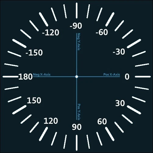
Course Angle[]
Angles in space agency (due to the inverted Y-axis) are measured clockwise from the positive X-axis. This ensures that 90 degrees remains in line with positive y-axis, the defining assumption for angles on Cartesian grids. A guide with every 10 degrees marked and every 30 degrees labelled is shown to the right for clarification. Also be aware that when calculating angles with arctan it is sometimes necessary to add or subtract 180 degrees, this can be determined by examining the sign of dx.
Getting the course angle nearly right is critical to successful Cartesian Navigation. While some corrections are to be expected in step 6, major corrections can waste fuel or result in overshooting the destination.
Alternatives[]
It's worth noting that NaviComp shows a waypoint arrow for known waypoints which is a visual indication of the course angle. If one can mimic this one can sometimes get close enough to known waypoints without the calculations.
One could also graph a line through two points with a graphing calculator or utility, but must be able to invert the y-axis (or negate it manually) and ensure the display is 1:1 scale to ensure the line is the correct direction.
Missions[]
The method makes for an exceptional shortcut in the following missions:
- Mission 12 - Solar Probes : Travel from HOM to SOL (~85 degrees), bypassing PUR. Flighting both probes in tandem it is possible to complete the mission in about 4 minutes.
- Mission 18 - Atmospheric Probe : Travel from HOM to GRN (~-75 degrees) bypassing LUN altogether.
- Mission 30 - Shuttle Rescue : Though the shuttle is drifting, one can still use this technique to reach it's initial location. The technique can also be use to return to STA if you stop.